Friday, August 5, 2016

Timberline Trail: Days 3 and 4!

-----Day 3, July 31st-----

On day 3 we continued our clockwise traverse of Mount Hood! We had A LOT of downed trees in our path on this  particular morning. It was a little frustrating and monotonous, yet still beautiful with the summit poking out from behind the burnt trees.


 After about a mile we came upon Coe Branch Creek. This creek is listed as the second hardest creek to cross on trail. It turned out to not be that bad! We walked upstream for a while and found an area where the river narrowed drastically, resulting in a very fast rush of water between two rocks. 


There seemed to be a log crossing that had been washed out. I leaped across the rocks with my go-go-gadget legs, and I found a long branch nearby to re-build the crossing! 


Not as sturdy as it probably once was, but I felt pretty accomplished and happy that I could benefit future hikers. (At least until the afternoon, when the swollen river will probably deconstruct my bridge.)

We had a BEAUTIFUL next four miles.. Small waterfalls were flowing in every little valley that we crossed in and out of. Beautiful wildflowers and views of Mt. Adams at our backs while we continued on the perfect day! 


Eventually we approached the Elliot Branch Creek. Way back in November 2006, the Elliot Glacier experienced a huge washout that created a few landslides and completely wiped out the trail crossing. Since then the trail has technically be "indefinitely closed", yet many hikers still scramble down a steep 300 ft slide area with the help of a precarious rope left by other hikers, and cross the sometimes dangerous creek, to complete the Timberline circuit hike. 

I did not take and do not own the picture below. It is a good visual and reference of the current trail condition: 


When we stopped to buy the map on the way up to Timberline Lodge, I had asked the employee there about any current information on the crossing, as most online information about the matter is very outdated. He told me he had been across a few days earlier, and said we should have no problem crossing based on our recent 900+ miles on the PCT.

All pictures in the remainder of this blog entry are originals taken by myself:

Looking down towards the washout. If you look very closely on the middle right side of the picture, you can see the faint "trail" that we would be using to exit the valley on the other side.

Our nearly vertical rope descent.

And our descending view.

Claire at the bottom of the rope, there was about 100 feet or so no-rope section down past where I was standing for this shot.

The actual river crossing was not that bad. We just had to get our feet wet :)

Scrambling up the ther side looking back into the valley.

After climbing out of the valley and finding the trail again, we ascended up towards Cooper Spur. The East side of Mt. Hood is very arid and hot, with a lot of the trail consisting of barren landscapes. 


In the next few miles we climbed way up high and crossed about 6 or 7 snow patches. When we hit the very top of Lamberson Spur, we took a victory mountain selfie at the highest point on the Timberline trail at 7,300 ft. On the way down, I even got to glissade down a snow chute!


After descending out of the snow, we continued to descend down Gnarl Ridge and to loop around Lamberson Butte. The wildflowers returned in full force, and we continued to be rewarded with awesome views!


After a looooong descent, we did a wet crossing of Newton Creek, our final crossing of the day. There were some occupied campsites just after the river, but some nice people told us about a vacant site tucked away a few hundred feet up the hill in the trees. It was still early in the evening, but after a long climb and decent, and a few difficult river crossings over 11 miles, we were ready for some rest!

-----Day 4, August 1st-----

On the morning of our 4th day we made our way towards Mt. Hood Meadows, the place where Claire and I snowboard and ski in the winter. There were beautiful flowers and waterfalls left and right! (This has been a recurring theme on this hike :)


It was really crazy to walk through some of the same ski runs that I'm usually boarding down in 5+ feet of snow! 


See the chair lift in the back?

After a short food break and a picture perfect photo session with somw purple wildflowers and Mt. Jefferson, we were already leaving Mt. Hood Meadows ski resort. 


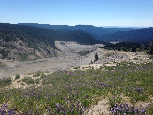
We started a long descent down to White  River. Again, the crossing was not difficult but approaching and leaving the river valley was very tiring and strenuous. This picture is looking back down at the huge sandy ravine:


The day was hot, the sand was deep, the grade was steep, and we trudged up a giant hill for the last few miles of our hike! The trail was a few feet from a very high and vertical drop to our right. At one point I felt the ground shake and heard a great noise nearby made from the dislodging of a few big boulders. They crashed down the sandy cliffs, making a big cloud of dust not 30 feet away from where I stood!


Soon we could see the Timberline Lodge, our starting point!!


Although we had only done 6.8 miles on this last day, we had to go celebrate our trip of 40+ miles in just 72 hours around our favorite mountain! We stopped by El Burro Loco on the way back down towards town, and you BET we got the nachos! :) 


It was definitely a very fun trip. A little more physically challenging than I thought it would be for some reason, butt assume it's just because our bodies finally got used to NOT walking 17-20 miles a day like on the PCT! 

I appreciate everyone who is still following this blog and is checking out what we're up to. I don't have to be making these, but the great feeling I get from people telling me how inspired they are and the appreciation of the photos I post make me strive to keep producing new material about our trips! Feel free to leave me some comments or questions and I'll make sure to continue posting our summer adventures! Until next time! And as always,

Thanks for reading!!

Thursday, August 4, 2016

Timberline Trail: Days 1 and 2!


So what do two people who just walked over 900 miles in the spring/early summer do for the rest of their summer? They backpack more of course! Being back in Portland, we decided jto do a hike that had been on our lists since both of us moved here: the Timberline Trail. This challenging, 40 mile trail starts at the Historic Timberline Lodge. The trail traverses the contours of Mt. Hoods many valleys and ridges, while flaunting beautiful displays of seasonal wildflowers and stunning views of the peak from all sides of the mountain.

-----Day 1, July 29th-----

We took off Monday morning after doing some last minute food-shopping at the local Fred Meyers. On the way up to Mt. Hood on highway 26, we stopped in Zigzag for Claire to get some coffee and for me to pick up an Annual Northwest Forest Pass for the car (as mine had expired while on the PCT), and a super handy dandy map!


After passing through Givernment Camp, we took the windy Timberline Road up to the lodge! When we pulled up to park, we were instantly rewarded with this South side view of the summit:


We parked away from the main parking lots in the overnight parking, and I displayed my new Forest Pass on the dash. We went into the climbers room where climbers planning to summit Mt. Hood and also overnight wilderness hikers fill out free trip-permits. 

Dropping the permits off in a box near the trailhead, we were on our way! We decided to do the trail clockwise, but not for any particular reason. Perhaps because we had already done the first 6 miles of trail last summer, and we figured the familiar terrain would fly by, leaving the new and unexplored part of the trail for the end.

The trail starts off flat and goes under a few of the chair lifts of the Timberline Ski Resort. Soon, we stared a long descent towards Zigzag Canyon, and by mile 3 we were at the edge of the canyon, preparing to drop down:


Steeply down we dropped, our knees definitely remembered this hike from last September! The river crossing was not bad, and looking back up the canyon from the other side there was a neat little waterfall:


We started a steep climb out of the Canyon, and approached the Paradise Park Loop. This was the loop we had done late last summer. Remembering it's beauty, we decided to take the slightly longer, higher up trail to re-visit the area. The Timberline Trail has a few of these alternates (usually longer) that visit certain points of interest before rejoining the Timberline Trail again.  

Lots of Indian Paintbrush and Bear Grass lined the sides of the trail, making us quite happy to be outside!

Indian paint-brush

Bear Grass


Paradise park once again blew our minds as it did not even a year ago. Wide open vistas and views of Mt. Rainier in the distance. Just around the corner we got a sneak peak of Mt. Saint Helens as well.

Split rock 

Here I took a picture in the same spot as last summer, and I have the two pictures next to each other to compare. The first picture is last year in early September, when the fall colors made everything red and orange. The second picture was on this trip, (late July). The vibrant green foliage made for a pretty day:

Early September 2015

Late July 2016

After taking a little food break a top split rock, we started our long descent down to the Sandy River. This was the longest continuous decent of the trail, dropping 2,520 feet over about 5 miles. Along the way, we witnessed dramatic cliffsides and a few waterfalls way down below us.


As we lowered in elevation below 4000ft, we started to see many types of mushrooms of all different shapes and sizes. We even saw the rare and elusive smiley face shroom! 


When we finally made it down to the Sandy River, we ate a little more food and decided to cross it instead of waiting until the morning. I grabbed a few large tree branches and added to the makeshift crossing that it seems many others had contributed to. We crossed the raging river without getting to wet. 

Almost immediately after crossing, we stumbled upon our home for the night. It was only 7pm, but we were tired and ready for some rest. We particularly liked this spot because it was still in the lingering summer sun, and it was on soft sand, but far enough away from the river to be safe from unexpected swells of water level.


We enjoyed a beautiful mountain glow courtesy of the setting sun, and drifted off to sleep after an "easy" 10 mile day.


-----Day 2, July 30th-----

On day 2 we woke up at our beautiful campsite along the Sandy River and continued around Mt. Hood! In just half a mile, we came across Ramona Falls! A very pretty waterfall that spreads out and cascades down a large mossy wall:


It was funny to see early morning day hikers who had walked in 3.5 miles from the nearby Ramona Falls trailhead. Most were carrying just a water bottle and a phone, and then there was us with our big packs on with everything we needed for a few days.

After that we climbed up and around some pretty messy terrain, including crossing 3 forks of the Muddy Fork River and doing some bush-whacking, rock-hopping, and trail-finding along the way. We passed a series of steep, fragile, land slide areas where we took extra care not to be the cause of the next one!


After surviving the sketchy cliffs, we were rewarded with: 


Salmon Berries!! And lots of them! We picked and ate and picked and ate; we picked and ate more than we walked, which we were fine with! 


After our bellies had enough and were a little sore, we finally started walking once again at our normal pace. We passed Yocum ridge and approached Bald Mountain. Now here, hikers have an option of taking a short .1 mile cutoff trail to make the hike a 38.9 mile hike instead of 40.4, but we heard there were some awesome views to be had by walking the extra 1.5 miles around Bald Mountain, and we were not disappointed! 


We had planned to take the McNeil Point alternate, which takes hikers a little closer up for a nice view of Hood, but both of us missed the unmarked turnoff until we had well passed it. Instead, we got to see an awesome display of Bear Grass! How can grass be so exciting one might ask? Well, check it out!


Little lake reflection

Continuing on above Eden Park and around Cairn Basin, we were met with an old burn area as well as a GORGEOUS display of the most Indian Paint-brush I've ever seen!


And tons more Bear Grass too! 


It was stunning! The trail then opened up to an amazing vista where we could see three mountains all at the same time! The clarity of the photo is very lacking, but believe me, all three of them were showing their mountainous features loud and clear!

If you look verrrrrry closely you can see left to right: Mt. Saint Helens, Mt. Rainier, and Mt. Adams!

We remained in the burn area for the rest of the day. There were still plenty of flowers around as well as some views of Hood from a little different perspective than we were used to. 


You'd think we would get over the view of the summit as it's literally what we're hiking around and looking at most of the day, but in fact, it grew more majestic at every corner and was a brand new site from every side and angle of the mountain! 

We entered an area called Elk Cove, and we followed a sign that said "campsites", leading down a steep path. We came across a group of people camping, and then another, and then another!! Soon we had walked over a half mile and there was no vacant campsites! The trail started getting very messy and I maintained with many downed and burnt trees. We decided to give up and hike back out, dreading the thought of continuing on the main trail until we found something that could work for our tent.

As we were trudging back up the steep path towards the Timberline trail, I spotted a hidden flat spot behind a few burnt trees! Thank goodness we had to walk no further! We assessed the site and decided it would work for the night.

It wasn't the most glamorous of sites but we had walked over 13 1/2 miles and had seen A LOT! And we were ready for some rest. During the night, high winds blew through the burnt trees above us, and thoughts of our tent getting crushed made sleeping a little harder than usual..

Read the next blog entry for days 3 and 4!